Low Contact Community Engagement

Critical planning, design, and development projects need to move forward, even under difficult circumstances. How can we create opportunities for people to weigh in on projects that affect their neighborhoods, while maintaining a safe distance and reducing the risk of illness?A new publication, Guidelines for Low Contact Community Engagement, collects ideas and best practices that can be used now and as conditions begin to return to normal. The guidelines are organized into three phases:
Emerging from Lockdown: for use when physical distancing and stay-at-home recommendations are in place.
Living with COVID: for use when stay-at-home restrictions are lifted but physical distancing is still necessary.
A New Normal: for use as conditions gradually return to normal, recognizing that the challenges of COVID -19 may be with us for a long time and traditional community engagement practices will need to change to protect the health and safety of participants.

DOWNLOAD GUIDELINES as a PDF
READ GUIDELINES in issuu
The guidelines were developed in partnership with Bike Cleveland and Clevelanders in Motion, with funding from Racial and Ethnic Approaches to Community Health (REACH) grant from the Centers for Disease Control and Prevention through the Cuyahoga County Board of Health.The guidelines are a work in progress, intended to help public agencies and nonprofit organizations navigate the community engagement process under unprecedented public health challenges.
We welcome additional ideas for low-contact community engagement. We invite you to share what’s working for your community with our team at cudc@kent.edu.
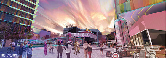
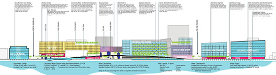
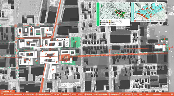
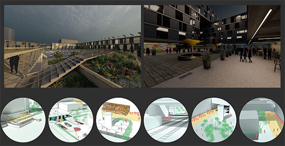
2020 ULI Hines Competition: Miami

This January, two teams of graduate students from Kent State University and Cleveland State University competed in the annual Urban Land InstituteHines Student Competition, a two-week competition presenting interdisciplinary student teams with a real-world challenge in the design & financing of large-scale urban developments.The 2020 site, announced on Day 1 of the competition, was in the city of Miami, FL, with a study area north of Downtown straddling the Wynwood and Edgewater neighborhoods. A regional rail line currently divides the site, but plans are underway to add a station somewhere in the site vicinity.

The competition brief emphasized the importance of multimodal transit, climate resiliency, affordability, and the integration of local arts & culture.The final schemes both integrated new rail stations, mixed use development, affordable housing, open space, and sensitivity to climate & stormwater considerations. Even with only two weeks to develop the project, the final boards submitted were unique and thoughtful, with complex design development at multiple scales.


The Blueway:


#Wynwoodyards:


You can view all the 2020 Hines Competition finalists here.
Congratulations to all our students for an intense and successful two weeks!
Urban Indeterminacy

As we struggle to adapt to the growing impacts of the coronavirus, it is increasingly apparent that volatility (in more than just public health) is the new normal; climate conditions, financial markets, political landscapes, and more will continue to shift in dramatic, quick, and unpredictable ways.
The built environment as we know it is in many ways resistant to the changes brought on by this kind of environmental, economic, and social context—buildings are costly to adapt, infrastructure can be notoriously vulnerable to shock, and most urban systems are not designed to be flexible and responsive. If you, like many of us, have suddenly found yourself with a lot of alone time for reading and an increasing sense of urgency about how indeterminacy impacts our cities, we’d like to recommend ‘Under the Brownstones, the Beach,’ an article by Ivy Pan & Foad Vahidi featured in our latest edition of Urban Infill, FUTURECITY.

Under The Brownstones The Beach (Image: Ivy Pan and Foad Vahidi)
The authors imagine a social realm that thrives in unpredictable times, particularly in relation to market volatility, through a network of impermanent, small-scale public spaces. They envision a flexible, reactive system that enables the appropriation of temporarily disused spaces within the city, like “a construction site halted in winter, a foundation pit vacated during an economic downturn, and a mound of rubble after demolition.”
The spaces are intimate, as a reaction to more common (and more market-supported) production of large-scale public spaces, and the system is persistent, even if none of their proposed individual social spaces is. Pan & Vahidi’s work can be found in the Adaptations section of FUTURECITY, along with other essays and research on how cities can be responsive to our changing world.

The publication interrogates many aspects of current and future urban challenges, also including pieces on data / privacy, automation, de-growth, and more. Order a copy of the book here, delivered right to the door of your temporarily socially isolated location.
Erie, PA: 2019 Community Design Charrette
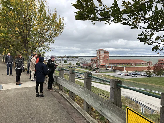
In October of 2019 the CUDC staff and 6 graduate students in Architecture, Urban Design, & Landscape Architecture traveled to Erie, PA for a 3-day urban design charrette. Hosted by the Jefferson Educational Society, the aim of the Charrette was to examine the existing conditions of Erie's Bayfront area, currently cut off from the Downtown & adjacent neighborhoods by a series of infrastructural, topographic, and programmatic barriers.


The design team was charged with envisioning new possibilities for connecting along & across these barriers, in order to more seamlessly integrate the Bayfront into the larger city & region. The students had frequent touchpoints with the Erie community throughout the charrette weekend, with daily presentations and informal check-ins to ensure their work was aligning with stakeholder needs.
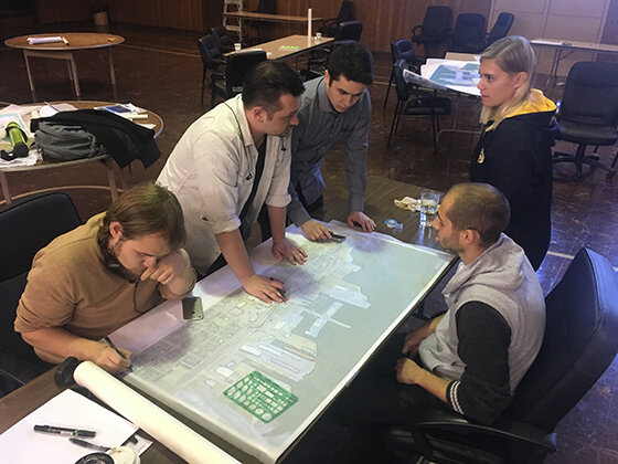


The final work, presented in draft form the final day of the charrette, compiled ideas ranging from small-scale wayfinding & materials to large-scale pedestrian networks, with space for public comment and final tweaks by the CUDC staff after the charrette weekend.


Green Bicentennial Pier

Temporary uses
The design team ultimately proposed not a single "iconic connection," but instead a series of pathways & crossings that could take on an iconic character and experiential quality in their own right. Larger-scale connections to new park spaces, Presque Isle, and elsewhere were examined, as well as ideas for landscaping, wayfinding, programming, four-season activation, public art, and maritime heritage.


Proposed pedestrian bridge
The final report, presented to the public at the Jefferson Educational Society by Project Manager Kristen Zeiber on January 30th, 2020, can be found on the Jefferson Educational Society website: Final Charrette Report

Bayfront conceptual plan
Special thanks to the Jefferson Educational Society for hosting a wonderful weekend, and to the Erie County Gaming Revenue Authority, the Erie Community Foundation, the Mastriana Endowment, and NAIOP for supporting the 2019 Community Design Charrette. Thanks also to Michael Fuhrman and John Vanco for their stalwart support & enthusiasm across the Charrette weekend and beyond!
Big Data & Urban Futures
The 8th issue of the CUDC's journal Urban Infill features a collection of articles about big data and smart cities including American City 2.5 by Anna Acklin and Mark Linder. Their article explores the application of geographic information system (GIS) software as a tool of urban design.

An excerpt:
The county-wide maps of American City 2.5 are a revision and expansion of a commission to study Onondaga Creek in Syracuse, New York, as a potential locus of public-private investment. American City 2.5 extends that study to an analysis and modeling of spatial data across the Onondaga County to distinguish latent communities, institutional networks, and public infrastructures through three general maps that capture the county’s economic, cultural, and hydrologic character. Exercising a variety of investigated techniques within the software, the project infuses census data into the map’s various layers, inviting a unique graphical representation of these newly designed or more informed components, territories, infrastructures, and ecologies that feed the site.Consider the land parcel. In its most basic sense, the parcel may be understood as boundary lines demarcating plots of land at the ownership scale.
In efforts to exhibit the economic character of plot ownership and neighborhoods across the county, the parcels are formally manipulated through GIS to varying degrees of distortion based on the population of college students, and are then color-coded on a gradient based on the proportion of the population without high school diplomas. The web-like feature created by this process reflects the emergence of a more bottom-up, or organic, understanding of the economic culture county-wide through the scale of the parcel.Similar operations were employed across the three base maps to manipulate features in accordance with census information to reveal the economic, cultural, and hydrologic latencies throughout Onondaga County. In pushing the graphic capacities of the software, the layers are accentuated and expressive of the now merged features and transformed census data, subverting the typical hierarchical understanding of mapped elements.

The hydrology and geographical features of Onondaga County, New York
While the images themselves are abstract, it is this very attribute that welcomes interpretation without discrimination and creative speculation. The image’s ability to re-present and inspire design proposals remains rooted in specificity, but can simultaneously confirm, accentuate, and/or elaborate intuitions in one’s understanding of a city. As an urban design tool, this capability creates an alternative understanding of site analysis and creates ranges of new potential within proposed solutions that can be more particular as they respond to a more informed site.
To read the complete article plus others on the themes of big data, development, and adaptation, you can pick up a copy of Urban Infill No. 8 at the CUDC for $10 or order it online.

If you're interested in big data and GIS as an urban design and community development tool, please join us for a lecture by Sarah Williams on MIT's Civic Data Design Lab on March 6, 2020 at 5:30 pm. Sarah will share some of the Lab’s work and discuss how big data can be used to generate policy change. Drinks and snacks at 5:30pm; Sarah’s talk begins at 6pm.Event is free and open to the public but registration is appreciated.
Presentation of Winning ZeroThreshold Competition Designs

In 2019, North Coast Community Homes sponsored a design competition seeking new ideas for for accessible housing, with funding from the Cleveland Foundation and technical support from the CUDC. The competition entries were exhibited at venues throughout Cleveland in late 2019 and a competition catalog is in the works.First prize went to the New York City-based Brandt : Haferd for their project SIDE by SIDE (pictured above) which incorporated the firm’s playful claymation model aesthetic with three major design principles to create an innovative, design-forward accessible house:
An Urban Approach
A New Take on the Multi Family/Communal House
Accessibility at Many Scales.
On February 13, 2020 at 4 pm, the Neighborhood Design Center, is hosting an exhibition and presentations by several of the winning designers at the NDC, 1445 Summit Street, Suite 300 in Columbus. For more information, contact the NDC at 614.221.5001 or info@columbusndc.org
Erie, Pennsylvania: Reconnecting the Bayfront

Presentation at the Jefferson Educational Society, 3207 State Street, Erie, Pennsylvania
JANUARY 30TH, 2020 | 7:00 PM - 8:30 PM
How can Erie better connect its bayfront with the downtown and adjacent neighborhoods? That was precisely the mission of the Cleveland Urban Design Collaboration when it came to Erie and the Jefferson Educational Society in late October, 2019 for an intensive weekend of study and design. The final report of the creative work by students and faculty of Kent State University's College of Architecture and Environmental design will be presented at the program, titled Erie, Pa: Reconnecting the Bayfront. That is also the title of the group's report published by the Jefferson Educational Society. Lead program presenter will be Professor Kristen Zeiber, urban designer.
Future Cities Book Release + Mariana Mogilevich Lecture

Book release for Urban Infill 8: Future City, featuring a lecture by Mariana Mogilevich entitled, Between Policy and Poetry
Friday, January 31, 2020
Reception and Book Release at 5:30pm | Lecture at 6pm
CUDC Gallery, 1309 Euclid Avenue, Suite 200, Cleveland
We're kicking off a year of celebrations marking the CUDC's 20th anniversary with a book release for the Volume 8 of the CUDC's journal, Urban Infill 8: FutureCity. FutureCity explores emerging ideas in urban design and city-making and features articles and interviews about the impacts of big data and the Smart Cities movement; contemporary development practices; and urban adaptation strategies.

Mariana Mogilevich will give a talk entitled Between Policy and Poetry: What can a publication contribute to the collective work of citymaking? A view from New York City. Mariana is the Editor-in-Chief of Urban Omnibus, a publication of the Architectural League of New York. Free and open to the public.
Co-sponsored by the American Planning Association's Cleveland Chapter. Event attendees are eligible for one hour of AICP Certification Maintenance (CM) credit. Urban Infill is made possible through the generous support of The George Gund Foundation.
Welcome to the new CUDC Website!
We begin the celebration of our 20th anniversary with a new website.
This will be our new home to share our work, events and thoughts with you. We hope that this is not always a one-way conversation and to have you join us in our events, for you to submit work for our future publications or to work with you as we take on new initiatives.
Thanks for your support and we look forward to the next 20 years.
